This hike was a part of my 2023 effort to hike the trails in the Hidden Valley area of the Warm Springs Ranger District in the George Washington National Forest.
I've been coming to this part of Virginia for over thirty years now, and spent my honeymoon nearby. But I've never hiked the trails in Hidden Valley, mainly because they are a couple hours drive away, the trails are not very tough, and I've had other hiking priorities. But now I'm working on all trails in this district, so I've been coming out here on days when I can get on the road very early.
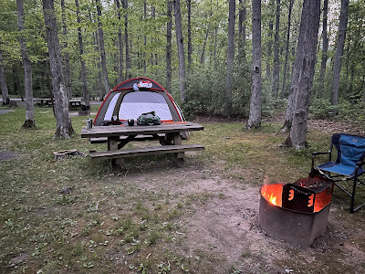
The Hidden Valley Recreation Area has a really nice campground, and I stayed here my previous time hiking here.
There are some trails that begin and end in the campground, and I hiked them when camping here, but they weren't very interesting and I did not write them up. (What is it about trails around National Forest camping areas? None seem very interesting.)
I came back a couple of months later for a day trip, seeking to check off two or three trails I had yet to encounter. On the way out, I realized that I had forgotten a critical piece of equipment - maybe I left a little too early. I was without hiking shoes (I wear trail runners from Hoka, and have been wearing Hokas for
well over 10 years - late 2011 or early 2012). I usually store them in the back of the car, and wear Crocks when driving. This time, I only had Crocs - so I had to hike in them. I've done that before, but my feet don't like them as much as Hokas.
I chose the Neil Run Trail, the Neil Run Spur Trail, and the Hidden Valley West Trail to complete. Not a lot of miles, but it was going to be a hot July day and I was in Crocs.
Let's get the spoiler out of the way right away. None of these trails were that great. And none of them were as long as shown on the map because they were overgrown at their far ends. (All are out-and-back with dead ends.) The fact that the trails are not as shown on the maps I reviewed was a bit of a problem, as described below.
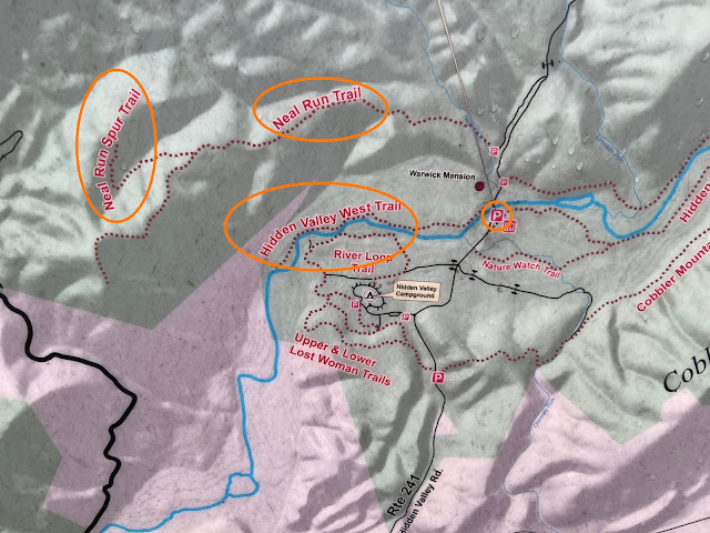
I started out at the main parking area, circled on the photo below. The three trails I hiked are also circled. After crossing over the Jackson River and passing the Warwick Mansion B&B, I hked north up FS 241 until I reached a brown hiker sign. I then hiked back south on an old, gated woods road. The map below shows that road as being open and a parking area at the south end. That no longer exists.
At the south end of the old road, I took a right and the trail became very overgrown. The Neil Run and Neil Run Spur are really for hunter access. They even open them up to disabled hunters to use motorized equipment during the hunting season. They get you into the woods but don't take you to any outstanding locations. A carsonite signpost states that the "road" is open to "4-wheels, atv's, and cycles," but closed to other motorized vehicles.

The trail climbs and the vegetation becomes much shorter. For much of the climb, the forest is very thin on the right and much thicker on the left, signifying that the woods had been thinned of the prime timber at some time in the past. At about the 1.5 mile mark into the hike an old woods road descended to the left. It wasn't on any map, and I figured it might be the road taken back in the day to haul timber out. It looked like a shortcut on the way back, because it dropped down towards the Jackson River near the end of the Jackson River West Trail, as shown on my maps.
At 2.3 miles, there was a split in the trail. There was even a trail sign here, though the sign was flat on the ground. I've seen this on other trails in the Warm Springs District - the signs are new, but they are attached to posts sitting flat on the ground.
I cut right first and hiked to the end of the Neil Run Spur Trail. The end wasn't the same as what the map showed - where the map shows a dogleg right there was an overgrown turnaround, and after that the trail petered out to nothing.
I had a somewhat similar experience on the Neil Run Trail. It climbed and steadily became more overgrown until I reached a large down tree and there was no evidence of the trail after that. I retraced my steps to reach the old woods road at 4.6 miles. From here, I dropped steeply on a well defined old roadbed until I reached the bottom of the slope at Mile 4.9.
When the slope ended, I encountered a stream crossing amid incredible overgrowth. I wasn't in woods anymore, and moving was tough. I took off my pant legs and socks, and crossed the creek. The water felt great! In fact, I thought about hiking the creek all the way to the Jackson River, but it took me too far out of my way and the creek got deep in sections. So I exited on the other side and fought through all kinds of plants, getting scratched up along the way.
I also had to cross through a pond with lots of beaver activity - though I never saw any beavers or a dam. My progress was really slow, progressing only 0.3 miles in just over 30 minutes.
Just as I got to the Jackson River, I realized that I had passed right over the point where my GPS indicated that the Jackson River West Trail was located. If it had been there I would have seen it, so I continued into the river and walked upstream in the water back toward my car.
At a point where the GPS told me that the trail came very near the river, I got out, climbed up the bank, and failed to find a trail. But I was in a meadow and moving was easier through chest high grasses than it had been in the river.
I never saw evidence of the Jackson River West Trail until I got to the Warwick Mansion. Then, I found the trail - an old road then a mowed section of grass that ended at the river about 100 yards further upstream from where I got out. I hiked the whole thing, just to check that box.
In all, I hiked 6.6 miles in just under 4 hours. I still have a couple of Hidden Valley trails to finish off, but I know they will be in better shape than what I experienced because I've seen Facebook postings about recent work done to them.
 |
| My Route shown in Orange. (Previous Hike in Blue.) |
I didn't have the energy for any more hikes, so I took the long way home, driving back through Burnsville, the Bullpasture River Gorge, and McDowell before taking U.S. 250 back home. Some days, the trip to the trailhead and back is the highlight of the day - especially when that drive takes you through Highland County.


